The WVU G&G Remote Sensing Laboratory

Research Interests
My primary interest is in the spatial properties of images. The exploitation of image spatial properties offers the potential for not only improved image visualization and classification accuracies, but to facilitate completely new applications of remote sensing. For example, with the new commercial high resolution sensors, it may be possible to study individual objects, such as trees. This will move remote sensing from a focus on abstract pixels to the study of spatially explicit objects of interest.
Previous projects
Ailanthus altissima, or tree of heaven, is a highly invasive exotic tree from central China that appears to be spreading rapidly in the Eastern Deciduous Forest. In work sponsored by the USDA, Dr. McGraw, Distinguished Professor of Biology, and Dr. Landenberger, Research Assistant Professor, and I, have studied Ailanthus and its current landscape distribution as well as its dispersal and early growth patterns. The study drew on an earlier NSF-sponsored project (with the same group, as well as Assistant Research Professor and Post Doctoral Research Associate, Tomas Brandtberg) in which we investigated the optimal methods for delineating and classifying individual trees with high spatial resolution imagery and lidar data. Further information about our work can be obtained from the published papers (reprints
are available).
Other related interests
I also have an interest in thermal imagery, including the general analysis of night-time thermal imagery, normalization of daytime thermal data, and the fusion of multispectral thermal data with multispectral and hyperspectral visible and near-infrared imagery for both geological and urban applications..
Since 1999, WVU has participated in the Earth Imaging Consortium, an international remote sensing consortium, which has sponsored 11 graduate and undergraduate WVU students to participate in remote sensing courses in France and Greece. In addition, 13 students from France, Greece, Germany and Norway have attended similar courses at WVU. The project was originally funded by the US Department of Education FIPSE, and the European Union. Additional funding has been provided by the Eberly College of Arts and Sciences and the WVU Office of International Programs.
The West Virginia coalition of remote sensing organizations, West Virginia View, has current partners: WVU, Marshall University, Glenville State College, Davis and Elkins College, West Virginia Wesleyan College, the WV GIS Technical Center, Canaan Valley Institute, WV Department of Environmental Protection, NASA IV&V Educator Resource Center, the USDA Forest Service's Northeasetern Area State and Private Forestry Field Office, and Skytruth. West Virginia View is currently funded by AmericaView, through a grant from the USGS.
Selected Past Projects
Automated identification of orchards and vineyards from high resolution satellite imagery (With: Karen Steinmaus, PNNL) (Sponsored by NIMA)
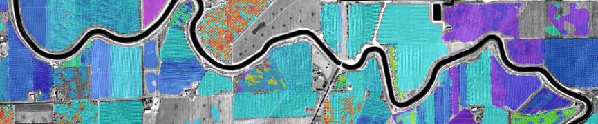
Automated identification of roads, rivers and forests in satellite imagery (with: Dr. Harris and Chetan Desai) (Sponsored by NIMA)
Automated identification of roads, rivers and forests in satellite imagery (with: Dr. Trevor Harris and Chetan Desai) (Sponsored by NIMA)
Spatial autocorrelation for data transformation
Band (feature) selection (With PNNL)
Multisensor landcover classification and data fusion (With: PNNL) (Sponsored by NIMA)
Geobotanical exploration for hydrocarbon microseeps (Sponsored by the US DOE, and NRCCE)
Student Research
Details about the research conducted by my past and current students can be found here.


